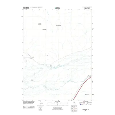
2012 Map of Stony Point
USGS Topo · Published 2012About this map
Stony Point Meadow sits at a critical bend in the Humboldt River, where the valley floor meets the rising slopes of the Sheep Creek Range and the Shoshone Range. This high-desert landscape in Lander County reflects a long history of resource utilization, from the thermal waters at Hot Springs to the industrial activity visible at the North Battle Mountain Mining Area. The map illustrates the region's agricultural footprint through established holdings like Jenkins Ranch, Blossom Ranch, and Argenta Ranch, which are concentrated near the winding river corridor. Transportation infrastructure is vital to this area, evidenced by the presence of Argenta Siding and a network of arterial routes including Frontage Rd and Rock Creek Rd that facilitate movement between the mining districts and the fertile valley bottoms of Boulder Valley.
Find a feature on this map
21 named features on this map. Tap any name to fly to it.
Don’t see what you’re looking for? This feature index may not catch every label — zoom into the map to look around manually.
Map Details
Editions of this 2012 Stony Point Map
This is the sole edition of this map. No revisions or reprints were ever made.
Other maps of this area

1955 · Winnemucca
USGS Topo · 1:250,000

1957 · Dunphy
USGS Topo · 1:62,500

1957 · Battle Mountain
USGS Topo · 1:62,500

1958 · Winnemucca
USGS Topo · 1:250,000

1962 · Winnemucca
USGS Topo · 1:250,000

1965 · Russells
USGS Topo · 1:24,000

1965 · Sheep Creek Range SW
USGS Topo · 1:24,000
1965 · Izzenhood Spring
USGS Topo · 1:24,000
1985 · Battle Mountain
USGS Topo · 1:24,000
1985 · Stony Point
USGS Topo · 1:24,000