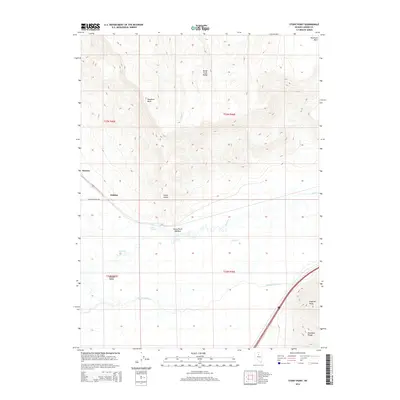
2014 Map of Stony Point
USGS Topo · Published 2014About this map
The Humboldt River carves through this high desert landscape, defining the transition from the Boulder Valley to the surrounding uplands of the Shoshone Range. This 2014 survey documents a region where water management and ranching infrastructure predominate, seen in features like the T-S Ditch and Stony Point Meadow. The topographic detail highlights the dramatic elevations of Shoshone Mesa and the Sheep Creek Range, which overlook the valley floor. Near the base of these heights, Hot Springs and numerous creeks such as Sheep Cr and Battle Cr flow toward the river basin. Small developments like Rennox and Jenkins sit along the primary transport corridor near Blossom Ranch Rd, illustrating the sparse but deliberate settlement pattern of modern Lander County. Researchers can trace the varied terrain from the peak of Argenta Point down to the fertile river flats at Stony Point.
Find a feature on this map
20 named features on this map. Tap any name to fly to it.
Don’t see what you’re looking for? This feature index may not catch every label — zoom into the map to look around manually.
Map Details
Editions of this 2014 Stony Point Map
This is the sole edition of this map. No revisions or reprints were ever made.
Other maps of this area

1955 · Winnemucca
USGS Topo · 1:250,000

1957 · Dunphy
USGS Topo · 1:62,500

1957 · Battle Mountain
USGS Topo · 1:62,500

1958 · Winnemucca
USGS Topo · 1:250,000

1962 · Winnemucca
USGS Topo · 1:250,000

1965 · Russells
USGS Topo · 1:24,000

1965 · Sheep Creek Range SW
USGS Topo · 1:24,000
1965 · Izzenhood Spring
USGS Topo · 1:24,000
1985 · Battle Mountain
USGS Topo · 1:24,000
1985 · Stony Point
USGS Topo · 1:24,000