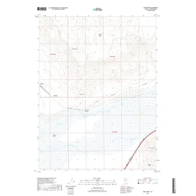
2018 Map of Stony Point
USGS Topo · Published 2018About this map
Stony Point Meadow sits at the geological heart of this Lander County terrain, where the northern high ground of the Sheep Creek Range meets the broad wetlands of Boulder Valley. The hydrology of the area is defined by the Humboldt River and the T-S Ditch, which support the low-lying basin floor beneath Shoshone Mesa. Cultural traces are concentrated along the northern corridor of Rock Creek Rd, where the small settlements of Rennox and Jenkins are situated. This 2018 survey also identifies hydrothermal activity at the Hot Springs near the center of the quadrangle. The map captures a landscape of extreme contrast, from the prominent heights of Argenta Point in the Shoshone Range to the complex irrigation networks and riparian zones that characterize the valley floor.
Find a feature on this map
22 named features on this map. Tap any name to fly to it.
Don’t see what you’re looking for? This feature index may not catch every label — zoom into the map to look around manually.
Map Details
Editions of this 2018 Stony Point Map
This is the sole edition of this map. No revisions or reprints were ever made.
Other maps of this area

1955 · Winnemucca
USGS Topo · 1:250,000

1957 · Dunphy
USGS Topo · 1:62,500

1957 · Battle Mountain
USGS Topo · 1:62,500

1958 · Winnemucca
USGS Topo · 1:250,000

1962 · Winnemucca
USGS Topo · 1:250,000

1965 · Russells
USGS Topo · 1:24,000

1965 · Sheep Creek Range SW
USGS Topo · 1:24,000
1965 · Izzenhood Spring
USGS Topo · 1:24,000
1985 · Battle Mountain
USGS Topo · 1:24,000
1985 · Stony Point
USGS Topo · 1:24,000