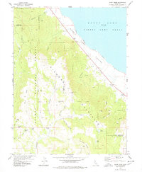
1978 Map of Stony Ridge
USGS Topo · Published 1978About this map
The Diamond Mountains dominate this 1970s landscape, marking the transition from high-elevation peaks down to the Honey Lake Valley floor. This era is defined by the significant military footprint along the western shore of Honey Lake, where the Sierra Army Depot occupies the lakeside flats. Small-scale ranching and remote outposts like Clark Ranch and Ophelia represent the sparse settlement patterns of the period, while the Plumas National Forest land is crisscrossed by a network of drainage systems, including Cottonwood Creek and Stony Creek. Numerous named water sources, such as Dinky Spring and Round Mtn Spring, suggest the critical importance of water management in this arid Lassen County environment. Topographical detail captures the steep descents of Wales Canyon and Brockman Canyon toward the valley below.
Find a feature on this map
38 named features on this map. Tap any name to fly to it.
Don’t see what you’re looking for? This feature index may not catch every label — zoom into the map to look around manually.
Map Details
Editions of this 1978 Stony Ridge Map
This is the sole edition of this map. No revisions or reprints were ever made.
Other maps of this area

1886 · Honey Lake
USGS Topo · 1:250,000

1891 · Honey Lake
USGS Topo · 1:250,000

1893 · Honey Lake
USGS Topo · 1:250,000

1950 · Kettle Rock
USGS Topo · 1:62,500

1950 · Milford
USGS Topo · 1:62,500

1954 · Susanville
USGS Topo · 1:62,500

1954 · Litchfield
USGS Topo · 1:62,500

1955 · Westwood
USGS Topo · 1:250,000

1958 · Westwood
USGS Topo · 1:250,000

1959 · Westwood
USGS Topo · 1:250,000