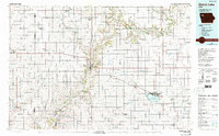
1985 Map of Storm Lake
USGS Topo · Published 1993About this map
Storm Lake serves as the central focal point for this Northwest Iowa region, which was photoinspected in 1990 to verify the enduring landscape of its agricultural and rail-dependent communities. The map details the transition of the regional economy through the presence of the Illinois Central Gulf and Chicago and North Western railroads, which connect key grain and transport hubs like Cherokee, Aurelia, and Sioux Rapids. Educational and recreational hubs are prominent, from Buena Vista College on the lake's northern shore to Mill Creek State Park and the Wanata State Forest Reserve further north. The winding path of the Little Sioux River and the North Raccoon River defines the drainage patterns of this prairie landscape, punctuated by small municipal airstrips like the Paulina Municipal Airport. This record preserves the late-twentieth-century layout of Buena Vista, Cherokee, and O'Brien counties before significant shifts in rural infrastructure occurred.
Find a feature on this map
123 named features on this map. Tap any name to fly to it.
Don’t see what you’re looking for? This feature index may not catch every label — zoom into the map to look around manually.
Map Details
Editions of this 1985 Storm Lake Map
3 editions found
Other maps of this area

1954 · Fairmont
USGS Topo · 1:250,000

1954 · Fort Dodge
USGS Topo · 1:250,000

1955 · Sioux City
USGS Topo · 1:250,000

1955 · Sioux Falls
USGS Topo · 1:250,000

1957 · Fort Dodge
USGS Topo · 1:250,000

1958 · Sioux City
USGS Topo · 1:250,000

1958 · Sioux Falls
USGS Topo · 1:250,000

1958 · Fort Dodge
USGS Topo · 1:250,000

1958 · Fairmont
USGS Topo · 1:250,000

1959 · Sioux City
USGS Topo · 1:250,000