1985 Map of Storm Lake
USGS Topo · Published 1993About this map
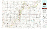
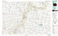
Storm Lake dominates the southeast corner of this survey, anchored by the namesake city and the campus of Iowa Central Community College. The landscape is a complex network of prairie waterways, where the Little Sioux River meanders through the heart of the region, passing the Wanata State Forest Reserve and numerous county parks like Dog Creek County Park and Kindlespire County Park. The era's transportation infrastructure is clearly defined, showing the prominent routes of the Illinois Central Gulf and Chicago Milwaukee St Paul and Pacific railroads as they connect rural trade centers like Cherokee, Aurelia, and Paullina. These rail lines, alongside highways such as U.S. 59 and U.S. 71, illustrate the mid-20th-century dependence on both rail and road for moving agricultural goods. Smaller, localized features such as Mary Hill and the Silver Sioux County Recreation Area provide specific landmarks for those tracing the historical geography of Northwest Iowa.
Find a feature on this map
86 named features on this map. Tap any name to fly to it.
Don’t see what you’re looking for? This feature index may not catch every label — zoom into the map to look around manually.
Map Details
Editions of this 1985 Storm Lake Map
3 editions found

Other maps of this area

1954 · Fairmont
USGS Topo · 1:250,000

1954 · Fort Dodge
USGS Topo · 1:250,000

1955 · Sioux City
USGS Topo · 1:250,000

1955 · Sioux Falls
USGS Topo · 1:250,000

1957 · Fort Dodge
USGS Topo · 1:250,000

1958 · Sioux City
USGS Topo · 1:250,000

1958 · Sioux Falls
USGS Topo · 1:250,000

1958 · Fort Dodge
USGS Topo · 1:250,000

1958 · Fairmont
USGS Topo · 1:250,000

1959 · Sioux City
USGS Topo · 1:250,000