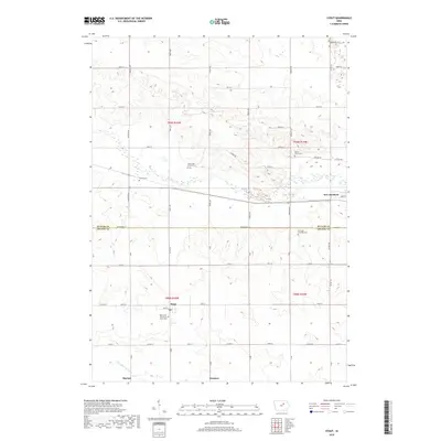
2018 Map of Stout
USGS Topo · Published 2018About this map
Stout and New Hartford anchor this agricultural landscape along the boundary of Butler and Grundy counties. The topography is defined by the winding course of Beaver Creek and the N Fork Black Hawk Creek, which carve through the Iowa plains. For local historians and genealogists, the map is remarkably detailed in its identification of several burial grounds, including the Beaver Grove, Fairfield Township, and Codner cemeteries. The settlement of Stout is centered on the Reformed Church of Stout and its namesake Stout Cemetery, while smaller locales like Sinclair and Swanton mark former rail or road junctions. The sectioned grid of the Public Land Survey System remains the dominant framework for the region, organizing the numerous farm roads and homesteads that define this rural corridor.
Find a feature on this map
47 named features on this map. Tap any name to fly to it.
Don’t see what you’re looking for? This feature index may not catch every label — zoom into the map to look around manually.
Map Details
Editions of this 2018 Stout Map
This is the sole edition of this map. No revisions or reprints were ever made.
Other maps of this area

1954 · Waterloo
USGS Topo · 1:250,000

1955 · Waterloo
USGS Topo · 1:250,000

1971 · Zaneta
USGS Topo · 1:24,000

1971 · Shell Rock
USGS Topo · 1:24,000

1971 · Dike
USGS Topo · 1:24,000

1971 · Coster
USGS Topo · 1:24,000

1971 · Stout
USGS Topo · 1:24,000
1971 · New Hartford
USGS Topo · 1:24,000

1979 · Holland
USGS Topo · 1:24,000

1979 · Butler Center
USGS Topo · 1:24,000