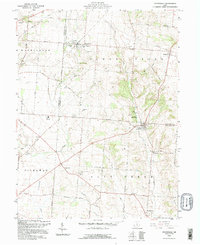
1992 Map of Stoutsville
USGS Topo · Published 1995About this map
Stoutsville serves as a primary rail hub in the northwest corner of this landscape, situated along the Southern Railway. The terrain transitions from the agricultural flats of W A S H I N G T O N and S A L T C R E E K townships into the rising elevations of Chestnut Ridge and Pumpkin Ridge. A network of historic thoroughfares, including the Zane Trail and Circleville Tarlton Road, connects small settlements like Leistville and Huntsville to the larger village of Tarlton.
Find a feature on this map
67 named features on this map. Tap any name to fly to it.
Don’t see what you’re looking for? This feature index may not catch every label — zoom into the map to look around manually.
Map Details
Editions of this 1992 Stoutsville Map
This is the sole edition of this map. No revisions or reprints were ever made.
Other maps of this area

1906 · Chillicothe
USGS Topo · 1:62,500

1907 · Lancaster
USGS Topo · 1:62,500

1908 · Chillicothe
USGS Topo · 1:62,500

1909 · Lancaster
USGS Topo · 1:62,500

1910 · Laurelville
USGS Topo · 1:62,500

1912 · Laurelville
USGS Topo · 1:62,500

1914 · Circleville
USGS Topo · 1:62,500

1943 · Circleville
USGS Topo · 1:62,500

1944 · Laurelville
USGS Topo · 1:62,500

1947 · Columbus
USGS Topo · 1:250,000