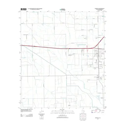
2013 Map of Stowell
USGS Topo · Published 2013About this map
Winnie and Stowell anchor this coastal Texas landscape, where a sophisticated network of irrigation and drainage infrastructure defines the local geography. The extensive reach of the Devers Main Canal, alongside its branches like Devers-E-Canal and Devers-F-Canal, highlights the region's historical reliance on managed water for agriculture. These man-made channels intersect natural waterways such as Spindletop Bayou and Onion Bayou, creating a hybrid landscape of natural drainage and engineered irrigation. To the south, the Sea Breeze Oil Field signifies the industrial energy presence that has long shaped the economy of Chambers County. Genealogists will find the Fairview Cem on the outskirts of Winnie, while the Chambers County-Winnie Stowell Airport serves as a modern landmark between the two primary settlements.
Find a feature on this map
81 named features on this map. Tap any name to fly to it.
Don’t see what you’re looking for? This feature index may not catch every label — zoom into the map to look around manually.
Map Details
Editions of this 2013 Stowell Map
This is the sole edition of this map. No revisions or reprints were ever made.
Other maps of this area

1943 · Whites Bayou
USGS Topo · 1:24,000

1943 · Sea Breeze
USGS Topo · 1:24,000

1943 · Stowell
USGS Topo · 1:24,000

1945 · Nolte
USGS Topo · 1:31,680

1945 · Sea Breeze
USGS Topo · 1:31,680

1950 · Houston
USGS Topo · 1:250,000

1956 · Houston
USGS Topo · 1:250,000
1961 · Monroe City
USGS Topo · 1:24,000
1961 · Oyster Bayou
USGS Topo · 1:24,000
1961 · Whites Bayou
USGS Topo · 1:24,000