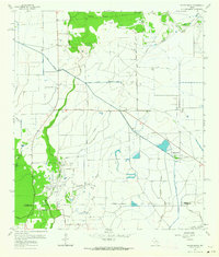
1961 Map of Whites Bayou
USGS Topo · Published 1964About this map
Whites Bayou and a complex network of man-made irrigation structures define this coastal Texas landscape, where the agricultural legacy of the rice industry is written into the terrain. The presence of the West Branch Devers Canal and East Branch Devers Canal demonstrates the sophisticated water management required to support the local economy. Rural life is anchored by family-named landmarks and essential community sites such as Sahara Cem, Freeman Cem, and the Abshier Cem, providing valuable touchpoints for genealogical research. The map captures a moment when petroleum extraction was an active part of the landscape, evidenced by numerous Oil Wells and a Disposal Well scattered near Sparks. Transportation routes like the Rice Belt Road and the Hankamer Loop follow the low-lying drainage patterns, connecting isolated woodlots like Devers Woods to the surrounding marshes and bayous.
Find a feature on this map
30 named features on this map. Tap any name to fly to it.
Don’t see what you’re looking for? This feature index may not catch every label — zoom into the map to look around manually.
Map Details
Editions of this 1961 Whites Bayou Map
This is the sole edition of this map. No revisions or reprints were ever made.
Other maps of this area

1942 · Anahuac
USGS Topo · 1:24,000

1943 · Whites Bayou
USGS Topo · 1:24,000

1943 · Liberty
USGS Topo · 1:125,000

1943 · Stowell
USGS Topo · 1:24,000

1945 · Nolte
USGS Topo · 1:31,680

1950 · Houston
USGS Topo · 1:250,000

1954 · Beaumont
USGS Topo · 1:250,000

1955 · Daisetta
USGS Topo · 1:62,500

1955 · Sour Lake
USGS Topo · 1:62,500

1956 · Houston
USGS Topo · 1:250,000