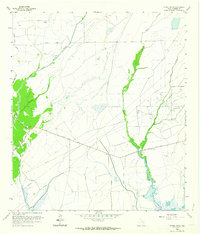
1961 Map of Oyster Bayou
USGS Topo · Published 1964About this map
Whites Ranch serves as a central landmark in this coastal prairie landscape of Chambers County during the early 1960s. The map illustrates a transitional economy where traditional ranching meets the growing petroleum industry, evidenced by the extensive Oyster Bayou Oil Field and numerous Oil Wells and pipelines crossing the terrain. The hydrological network is well-defined by the winding courses of Oyster Bayou and Double Bayou, which dominate the low-lying topography.
Find a feature on this map
18 named features on this map. Tap any name to fly to it.
Don’t see what you’re looking for? This feature index may not catch every label — zoom into the map to look around manually.
Map Details
Editions of this 1961 Oyster Bayou Map
3 editions found
Other maps of this area

1931 · High Island
USGS Topo · 1:24,000

1931 · Frozen Point
USGS Topo · 1:24,000

1933 · Frozen Point
USGS Topo · 1:31,680

1933 · Whites Lake
USGS Topo · 1:31,680

1942 · Anahuac
USGS Topo · 1:24,000

1943 · High Island
USGS Topo · 1:31,680

1943 · Frozen Point
USGS Topo · 1:24,000
1943 · Lake Stephenson
USGS Topo · 1:24,000

1943 · Sea Breeze
USGS Topo · 1:24,000

1943 · Stowell
USGS Topo · 1:24,000