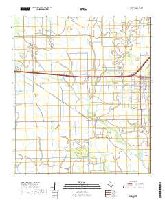
2019 Map of Stowell
USGS Topo · Published 2019About this map
The neighboring coastal prairie communities of Winnie and Stowell anchor this 2019 survey of Chambers County, where a complex network of man-made waterways like the Devers Canal and Ogden Ditch intersect with natural drainage systems. The landscape is defined by its low-lying hydrology, featuring the winding course of Spindletop Bayou and several smaller tributaries including Elm Bayou and Onion Bayou. To the southeast, the small settlement of Figridge sits near Marshall Estate Lake Number 1, illustrating the area's transition toward the coastal marshes. Local infrastructure and community history are represented by the Chambers County-Winnie Stowell Airport and the centrally located Fairview Cemetery. The map detail captures the grid-like residential streets of Winnie, such as Magnolia Avenue and Broadway Avenue, providing a clear view of the town's modern development alongside the primary transit corridors of FM 1406 and Interstate 10.
Find a feature on this map
69 named features on this map. Tap any name to fly to it.
Don’t see what you’re looking for? This feature index may not catch every label — zoom into the map to look around manually.
Map Details
Editions of this 2019 Stowell Map
This is the sole edition of this map. No revisions or reprints were ever made.
Other maps of this area

1943 · Whites Bayou
USGS Topo · 1:24,000

1943 · Sea Breeze
USGS Topo · 1:24,000

1943 · Stowell
USGS Topo · 1:24,000

1945 · Nolte
USGS Topo · 1:31,680

1945 · Sea Breeze
USGS Topo · 1:31,680

1950 · Houston
USGS Topo · 1:250,000

1956 · Houston
USGS Topo · 1:250,000
1961 · Monroe City
USGS Topo · 1:24,000
1961 · Oyster Bayou
USGS Topo · 1:24,000
1961 · Whites Bayou
USGS Topo · 1:24,000