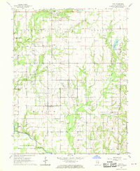
1968 Map of Stoy
USGS Topo · Published 1970About this map
Stoy and Oil Center stand as focal points in this mid-century landscape dominated by the regional petroleum industry. Numerous Oil Wells and a Gas Well are scattered across the terrain, particularly within the designated Gas Field and areas marked as Consolidated. The northern edge of the map is defined by the Illinois Central railroad line, while the Embarras River meanders through the southwest corner, providing a natural contrast to the industrial infrastructure.
Find a feature on this map
41 named features on this map. Tap any name to fly to it.
Don’t see what you’re looking for? This feature index may not catch every label — zoom into the map to look around manually.
Map Details
Editions of this 1968 Stoy Map
2 editions found
Other maps of this area

1910 · Hardinville
USGS Topo · 1:62,500

1917 · Birds
USGS Topo · 1:62,500

1942 · Birds
USGS Topo · 1:62,500

1953 · Indianapolis
USGS Topo · 1:250,000

1956 · Indianapolis
USGS Topo · 1:250,000

1956 · Annapolis
USGS Topo · 1:62,500

1956 · Vincennes
USGS Topo · 1:250,000

1957 · Indianapolis
USGS Topo · 1:250,000

1957 · Vincennes
USGS Topo · 1:250,000

1957 · Hutsonville
USGS Topo · 1:62,500