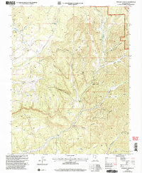
2002 Map of Straight Canyon
USGS Topo · Published 2005About this map
The North Fork Virgin River carves through this high-altitude landscape of southern Utah, defining a complex network of drainages within the Dixie National Forest. This 2002 revision, based on earlier topographic data and updated Forest Service surveys, reveals a terrain shaped by dramatic elevation shifts from the Pink Cliffs in the northeast to the deep incisions of Straight Canyon and Orderville Gulch. The map identifies critical water sources in an arid environment, including Bulloch Spring, Lower Bear Spring, and Big Springs. Infrastructure is sparse, limited primarily to a Gaging Station on the river and a Prospect located near the mouth of Willow Creek, hinting at early mineral exploration. The presence of named plateaus like The Plans and Table Bench illustrates the classic mesa-and-canyon morphology of Kane County.
Find a feature on this map
33 named features on this map. Tap any name to fly to it.
Don’t see what you’re looking for? This feature index may not catch every label — zoom into the map to look around manually.
Map Details
Editions of this 2002 Straight Canyon Map
This is the sole edition of this map. No revisions or reprints were ever made.
Other maps of this area

1886 · Kanab
USGS Topo · 1:250,000

1953 · Cedar City
USGS Topo · 1:250,000

1954 · Orderville Canyon NW
USGS Topo · 1:24,000

1954 · Orderville Canyon SE
USGS Topo · 1:24,000

1957 · Orderville Canyon NE
USGS Topo · 1:24,000

1958 · Cedar City
USGS Topo · 1:250,000

1958 · Orderville
USGS Topo · 1:62,500

1958 · Cedar Breaks
USGS Topo · 1:62,500

1958 · Panguitch Lake
USGS Topo · 1:62,500

1962 · Cedar City
USGS Topo · 1:250,000