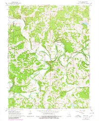
1966 Map of Strain
USGS Topo · Published 1980About this map
The Bourbeuse River carves a winding path through the borderlands of Gasconade and Franklin counties, defining the landscape around Champion City and Strain. This 1966 survey, updated with 1978 aerial revisions, reveals a rural economy heavily reliant on land extraction, indicated by the high density of claypits and pits scattered across the hills. The river’s path is marked by dramatic oxbows and landforms such as Bartel Bend and Kampschroeder Bend, where the water transitions from the main channel into tributaries like Little Bourbeuse River and Boone Creek.
Find a feature on this map
37 named features on this map. Tap any name to fly to it.
Don’t see what you’re looking for? This feature index may not catch every label — zoom into the map to look around manually.
Map Details
Editions of this 1966 Strain Map
2 editions found
Other maps of this area

1903 · Sullivan
USGS Topo · 1:125,000

1935 · Gerald
USGS Topo · 1:48,000

1941 · Gerald
USGS Topo · 1:62,500

1944 · Gerald
USGS Topo · 1:62,500

1946 · Union
USGS Topo · 1:62,500

1947 · Sullivan
USGS Topo · 1:62,500

1948 · Argo
USGS Topo · 1:24,000

1948 · Union
USGS Topo · 1:62,500

1948 · Oak Hill
USGS Topo · 1:24,000

1949 · Saint Louis
USGS Topo · 1:250,000