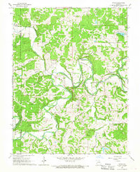
1966 Map of Strain
USGS Topo · Published 1967About this map
The Bourbeuse River carves a winding path through Franklin County, defining the local landscape with dramatic horseshoe turns like Kampschroeder Bend and Bartel Bend. During the mid-1960s, this area of Missouri maintained a rural character shaped by a network of small creeks including Kriete Creek and Hecht Creek. The settlement of Strain and the community of Champion City serve as the primary hubs, with social life centered on landmarks like New Friendship Ch, Champion City Ch, and School No 38.
Find a feature on this map
32 named features on this map. Tap any name to fly to it.
Don’t see what you’re looking for? This feature index may not catch every label — zoom into the map to look around manually.
Map Details
Editions of this 1966 Strain Map
2 editions found
Other maps of this area

1903 · Sullivan
USGS Topo · 1:125,000

1935 · Gerald
USGS Topo · 1:48,000

1941 · Gerald
USGS Topo · 1:62,500

1944 · Gerald
USGS Topo · 1:62,500

1946 · Union
USGS Topo · 1:62,500

1947 · Sullivan
USGS Topo · 1:62,500

1948 · Argo
USGS Topo · 1:24,000

1948 · Union
USGS Topo · 1:62,500

1948 · Oak Hill
USGS Topo · 1:24,000

1949 · Saint Louis
USGS Topo · 1:250,000