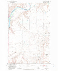
1953 Map of Stranahan
USGS Topo · Published 1977About this map
The Missouri River defines the northern landscape of this region, sweeping past Churchill Bend and the gravel deposit at Crow Coulee Bar. At this time in the early 1950s, the Great Northern railroad tracks follow the river's southern bank through the small settlement of Stranahan. The interior is marked by deep drainage patterns, specifically Crow Coulee and Rowe Coulee, which cut through the high plains. Evidence of shifting rural populations is visible in the presence of several former community centers, including the School (Aban'd) near the river and the East Wayside School (Aban'd) to the southeast. A small Landing Strip sits on the benchland, highlighting the importance of aerial access in this expansive Montana cattle and wheat country.
Find a feature on this map
12 named features on this map. Tap any name to fly to it.
Don’t see what you’re looking for? This feature index may not catch every label — zoom into the map to look around manually.
Map Details
Editions of this 1953 Stranahan Map
2 editions found
Other maps of this area

1890 · Fort Benton
USGS Topo · 1:250,000

1892 · Fort Benton
USGS Topo · 1:250,000

1897 · Fort Benton
USGS Topo · 1:250,000

1919 · Big Sandy
USGS Topo · 1:125,000

1953 · Boggs Island
USGS Topo · 1:24,000

1953 · Rocky Lake
USGS Topo · 1:24,000

1953 · Loma East
USGS Topo · 1:24,000

1953 · Verona
USGS Topo · 1:24,000

1953 · Big Bend School
USGS Topo · 1:24,000

1953 · Stranahan
USGS Topo · 1:24,000