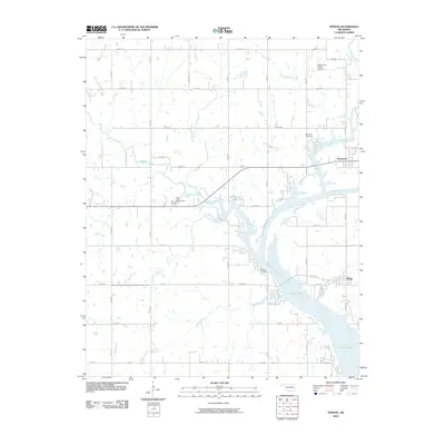
2010 Map of Strang
USGS Topo · Published 2010About this map
Strang and Pensacola anchor the eastern side of this landscape where the Neosho River widens into the northern reaches of Lake Hudson. The terrain is defined by a dense network of watercourses including Big Cabin Creek, Rock Creek, and Granny Branch that feed into the river system. In the western portion of the quadrangle, the City of Adair Waterworks is situated near the upper reaches of Rock Creek, while Stearmans Roost Airport sits in the northeast. Genealogists and local historians will find several established burial sites, such as Ghormley Cemetery and Benge Cemetery, the latter of which is located near the riverbank. The area's infrastructure is dominated by a grid of rural routes, notably Strang Rd and several numeric designations that connect the small settlements to the river's recreational and hydrologic resources.
Find a feature on this map
37 named features on this map. Tap any name to fly to it.
Don’t see what you’re looking for? This feature index may not catch every label — zoom into the map to look around manually.
Map Details
Editions of this 2010 Strang Map
This is the sole edition of this map. No revisions or reprints were ever made.
Other maps of this area

1896 · Pryor
USGS Topo · 1:125,000

1901 · Vinita
USGS Topo · 1:125,000

1901 · Pryor
USGS Topo · 1:125,000

1913 · Vinita
USGS Topo · 1:125,000

1954 · Tulsa
USGS Topo · 1:250,000

1958 · Tulsa
USGS Topo · 1:250,000

1963 · Tulsa
USGS Topo · 1:250,000

1969 · Adair
USGS Topo · 1:24,000

1970 · White Oak
USGS Topo · 1:24,000
1970 · Pryor
USGS Topo · 1:24,000