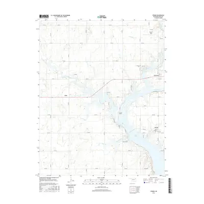
2016 Map of Strang
USGS Topo · Published 2016About this map
Lake Hudson dominates the eastern landscape of this 2016 survey, where the Neosho River flows through Mayes County. The settlement of Strang sits just east of the water, defined by a grid including Ross Ave and Hill Rd, while the town of Adair marks the western reach. This area is characterized by numerous small watercourses that feed the larger river system, including Armstrong Br, Benge Branch, and Rock Creek. Local history is preserved at the Ghormley Cem near Big Cabin Creek and the Benge Cem further south. Aviation is represented by both the Grand Isle Airport and Stearmans Roost Airport, the latter situated near the northern edge of the sheet. The landscape reflects a mix of established small-town centers and the sprawling water-management features of the Grand River Dam Authority's reservoir system.
Find a feature on this map
56 named features on this map. Tap any name to fly to it.
Don’t see what you’re looking for? This feature index may not catch every label — zoom into the map to look around manually.
Map Details
Editions of this 2016 Strang Map
This is the sole edition of this map. No revisions or reprints were ever made.
Other maps of this area

1896 · Pryor
USGS Topo · 1:125,000

1901 · Vinita
USGS Topo · 1:125,000

1901 · Pryor
USGS Topo · 1:125,000

1913 · Vinita
USGS Topo · 1:125,000

1954 · Tulsa
USGS Topo · 1:250,000

1958 · Tulsa
USGS Topo · 1:250,000

1963 · Tulsa
USGS Topo · 1:250,000

1969 · Adair
USGS Topo · 1:24,000

1970 · White Oak
USGS Topo · 1:24,000
1970 · Pryor
USGS Topo · 1:24,000