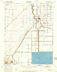
1940 Map of Stratford
USGS Topo · Published 1954About this map
Kings River irrigation and the reclaimed bed of Tulare Lake define the agricultural landscape of this Kings County region during the late 1930s. The map illustrates a complex network of water management, including the Empire Canal, Outside Canal, and Paso Robles Canal, which transformed this arid basin into a productive farming corridor. Small rural schoolhouses like Empire Sch and Jacobs Sch dot the grid of avenues, serving the dispersed labor force of the Blakeley Ranch and nearby settlements. At the southern edge, Kettleman City sits at the foot of the Kettleman Hills, where a Compressor Station indicates the importance of the local petroleum industry. The rail connection via the Southern Pacific at Westhaven Sta highlights the era's reliance on steel rails to move the valley's harvest to distant markets.
Find a feature on this map
52 named features on this map. Tap any name to fly to it.
Don’t see what you’re looking for? This feature index may not catch every label — zoom into the map to look around manually.
Map Details
Editions of this 1940 Stratford Map
This is the sole edition of this map. No revisions or reprints were ever made.
Other maps of this area

1912 · Coalinga
USGS Topo · 1:125,000

1914 · Lost Hills
USGS Topo · 1:125,000

1914 · Cholame
USGS Topo · 1:125,000

1915 · Cholame
USGS Topo · 1:125,000

1917 · Cholame
USGS Topo · 1:125,000

1926 · Hanford
USGS Topo · 1:31,680

1926 · Lethent
USGS Topo · 1:31,680

1927 · Lemoore
USGS Topo · 1:31,680

1929 · Guernsey
USGS Topo · 1:31,680

1929 · Stratford
USGS Topo · 1:31,680