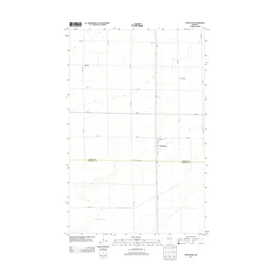
2013 Map of Strathcona
USGS Topo · Published 2013About this map
Strathcona serves as the central point of interest in this 2013 survey of the borderlands between Roseau and Marshall counties. The landscape is defined by the rigid precision of the Public Land Survey System, with gravel roads like 120th St and 190th Ave creating a geometric grid across the flat terrain. Local history is anchored by several rural burial grounds, including Bethlehem Cem in the northwest and Poplar Grove Cem to the east, which suggest the early settlement patterns of these farming townships. Water management is a primary feature of the region, evidenced by the extensive Judicial Ditch Number Nineteen and the naturally low-lying Thompsons Slough. The village of Strathcona itself remains concentrated near the Po and the junction of MN-32, which bisects the map as a major north-south transit corridor.
Find a feature on this map
23 named features on this map. Tap any name to fly to it.
Don’t see what you’re looking for? This feature index may not catch every label — zoom into the map to look around manually.
Map Details
Editions of this 2013 Strathcona Map
This is the sole edition of this map. No revisions or reprints were ever made.
Other maps of this area

1918 · Greenbush
USGS Topo · 1:62,500

1918 · Middle River
USGS Topo · 1:62,500

1919 · Pelan
USGS Topo · 1:62,500

1952 · Thief River Falls
USGS Topo · 1:250,000

1956 · Thief River Falls
USGS Topo · 1:250,000

1957 · Thief River Falls
USGS Topo · 1:250,000

1957 · Newfolden
USGS Topo · 1:62,500

1957 · Pelan
USGS Topo · 1:62,500
1961 · Middle River NE
USGS Topo · 1:24,000

1962 · Strathcona
USGS Topo · 1:24,000