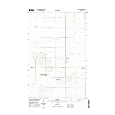
2016 Map of Strathcona
USGS Topo · Published 2016About this map
Strathcona sits at the heart of this northwestern Minnesota landscape, positioned along the border where Roseau Co and Marshall Co meet. The map reveals a highly structured agricultural grid, where long thoroughfares like 210th Ave and Co Hwy 27 divide the prairie into large rectangular parcels. This 2016 survey documents the persistent presence of early community anchors, including the Bethlehem Cem near the small settlement of Bethlehem and the Poplar Grove Cem to the east. The southern half of the map is dominated by the sprawling wetlands of Thompsons Slough and the engineered waters of Judicial Ditch Number Nineteen, illustrating the intensive drainage efforts required to maintain productivity in this low-lying region. These water features, alongside the Farm Service Agency Interest of Minnesota, highlight the interplay between natural hydrology and large-scale land management in the Red River Valley hinterlands.
Find a feature on this map
33 named features on this map. Tap any name to fly to it.
Don’t see what you’re looking for? This feature index may not catch every label — zoom into the map to look around manually.
Map Details
Editions of this 2016 Strathcona Map
This is the sole edition of this map. No revisions or reprints were ever made.
Other maps of this area

1918 · Greenbush
USGS Topo · 1:62,500

1918 · Middle River
USGS Topo · 1:62,500

1919 · Pelan
USGS Topo · 1:62,500

1952 · Thief River Falls
USGS Topo · 1:250,000

1956 · Thief River Falls
USGS Topo · 1:250,000

1957 · Thief River Falls
USGS Topo · 1:250,000

1957 · Newfolden
USGS Topo · 1:62,500

1957 · Pelan
USGS Topo · 1:62,500
1961 · Middle River NE
USGS Topo · 1:24,000

1962 · Strathcona
USGS Topo · 1:24,000