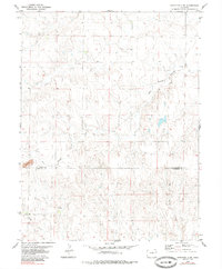
1979 Map of Stratton 3 SW
USGS Topo · Published 1985About this map
Big Spring Creek and East Branch Spring Creek define the drainage patterns of this High Plains landscape, where the border between Kit Carson Co and Cheyenne Co splits the central terrain. The map captures a primarily agricultural region during the late 1970s, characterized by a sparse network of section-line roads and scattered rural infrastructure. Evidence of local industry appears in the form of Gravel pits near the southwestern boundary, while the reliance on subterranean water is documented through locations of Springs and a documented Well. Significant seasonal watercourses like Pass Creek illustrate the natural erosion patterns across the open country, showing how water management and natural hydrology shaped the development of this Colorado borderland.
Find a feature on this map
7 named features on this map. Tap any name to fly to it.
Don’t see what you’re looking for? This feature index may not catch every label — zoom into the map to look around manually.
Map Details
Editions of this 1979 Stratton 3 SW Map
3 editions found
Other maps of this area

1891 · Arroyo
USGS Topo · 1:125,000

1891 · Kit Carson
USGS Topo · 1:125,000

1893 · Arroyo
USGS Topo · 1:125,000

1893 · Kit Carson
USGS Topo · 1:125,000

1954 · Limon
USGS Topo · 1:250,000

1954 · Lamar
USGS Topo · 1:250,000

1957 · Limon
USGS Topo · 1:250,000

1958 · Limon
USGS Topo · 1:250,000

1958 · Lamar
USGS Topo · 1:250,000

1978 · Sanders Ranch
USGS Topo · 1:24,000