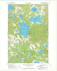
1969 Map of Strawberry Lake
USGS Topo · Published 1971About this map
Strawberry Lake sits at the heart of this Becker County landscape, which lies entirely within the White Earth Indian Reservation. In the late 1960s, the area was characterized by a dense network of glacial lakes and wetlands, including White Earth Lake and Big Rat Lake, interspersed with wooded regions like Maple Grove and Sugarbush. Local community life is anchored by the Strawberry Lake Ch and Strawberry Lake Sch, while a Townhall and several Gravel Pits indicate the rural infrastructure of the period. To the southeast, the Tamarac National Wildlife Refuge preserves the natural shoreline around Lost Lake, watched over by the Egg Lake Lookout Tower. The map provides detailed soundings for many of these waters, a result of collaboration between the USGS and the Minnesota Department of Conservation.
Find a feature on this map
30 named features on this map. Tap any name to fly to it.
Don’t see what you’re looking for? This feature index may not catch every label — zoom into the map to look around manually.
Map Details
Editions of this 1969 Strawberry Lake Map
This is the sole edition of this map. No revisions or reprints were ever made.
Other maps of this area

1953 · Brainerd
USGS Topo · 1:250,000

1954 · Bemidji
USGS Topo · 1:250,000

1957 · Brainerd
USGS Topo · 1:250,000

1957 · Bemidji
USGS Topo · 1:250,000

1958 · Bemidji
USGS Topo · 1:250,000

1958 · Brainerd
USGS Topo · 1:250,000

1959 · Flat Lake
USGS Topo · 1:24,000

1959 · Richwood
USGS Topo · 1:24,000

1959 · Height Of Land Lake
USGS Topo · 1:24,000

1965 · Brainerd
USGS Topo · 1:250,000