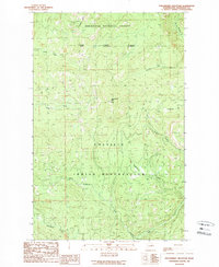
1989 Map of Strawberry Mountain
USGS Topo · Published 1989About this map
Colville Indian Reservation lands meet the Okanogan National Forest in this high-elevation wilderness corner of Washington. The topography is defined by the sharp rise of Strawberry Mtn and Dugout Mtn, creating a complex network of drainage basins. Numerous watercourses, including the W Fk Sanpoil R and Strawberry Creek, carve through the terrain, indicating a landscape dominated by natural watershed boundaries rather than human settlement. The survey illustrates the intersection of federal and tribal jurisdictions, marked by the National Indian Forest Reservation Boundary. While primarily forested and undeveloped, the network of unimproved roads and trails provides access to the interior, tracing paths along Gold Creek and Stepstone Creek that speak to the area's use for resource management and backcountry navigation in the late twentieth century.
Find a feature on this map
17 named features on this map. Tap any name to fly to it.
Don’t see what you’re looking for? This feature index may not catch every label — zoom into the map to look around manually.
Map Details
Editions of this 1989 Strawberry Mountain Map
2 editions found
Other maps of this area

1902 · Osoyoos
USGS Topo · 1:125,000

1904 · Osoyoos
USGS Topo · 1:125,000

1904 · Republic
USGS Topo · 1:125,000

1951 · Wauconda
USGS Topo · 1:62,500

1952 · Disautel
USGS Topo · 1:62,500

1953 · Bald Knob
USGS Topo · 1:62,500

1954 · Okanogan
USGS Topo · 1:250,000

1957 · Aeneas Valley
USGS Topo · 1:62,500

1958 · Okanogan
USGS Topo · 1:250,000

1958 · Aeneas
USGS Topo · 1:62,500