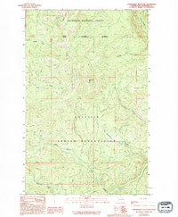
1989 Map of Strawberry Mountain
USGS Topo · Published 1994About this map
Colville Indian Reservation and Okanogan National Forest converge in this high-elevation mountain terrain during the late 20th century. The landscape is defined by its complex network of seasonal and perennial drainages, with the W Fk Sanpoil R carving through the northeastern corner. Prominent peaks like Strawberry Mtn and Dugout Mtn serve as the primary topographic anchors for the region, while the National Forest Boundary Indian Reservation Boundary illustrates the intersection of federal and tribal lands. This survey reflects a period of meticulous land management, capturing the precise flow of numerous tributaries including Sheep Creek, Roaring Creek, and Gold Creek. The drainage patterns, such as the winding Stepstone Creek and Loony Creek, provide essential data for understanding the watershed's hydrology and land-use divisions within the reservation and forest system.
Find a feature on this map
17 named features on this map. Tap any name to fly to it.
Don’t see what you’re looking for? This feature index may not catch every label — zoom into the map to look around manually.
Map Details
Editions of this 1989 Strawberry Mountain Map
2 editions found
Other maps of this area

1902 · Osoyoos
USGS Topo · 1:125,000

1904 · Osoyoos
USGS Topo · 1:125,000

1904 · Republic
USGS Topo · 1:125,000

1951 · Wauconda
USGS Topo · 1:62,500

1952 · Disautel
USGS Topo · 1:62,500

1953 · Bald Knob
USGS Topo · 1:62,500

1954 · Okanogan
USGS Topo · 1:250,000

1957 · Aeneas Valley
USGS Topo · 1:62,500

1958 · Okanogan
USGS Topo · 1:250,000

1958 · Aeneas
USGS Topo · 1:62,500