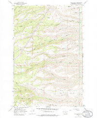
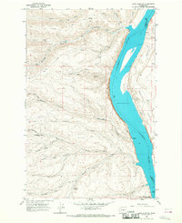
1966 Map of Stray Gulch
USGS Topo · Published 1986About this map
Tarpiscan Creek and its many branches define the high country of eastern Washington in the mid-1960s. This survey records a landscape shaped by water and elevation, where seasonal drainages like Stray Gulch and Tekison Creek carve deep into the plateau. The drainage patterns, including the South Fork Tarpiscan Creek and Brushy Creek, reveal a terrain accessible primarily by a network of utilitarian paths such as the Tarpiscan Road and various unnamed Pack Trails. A singular Quarry near the Caribou Perkins Road and a high-elevation Pipeline indicate the light industrial footprint on the land. Local history is anchored by specific water sources like Sheridan Spring and Hinkleman Spring, which were vital markers for livestock and travelers in this arid environment long before modern infrastructure reached the canyons.
Find a feature on this map
35 named features on this map. Tap any name to fly to it.
Don’t see what you’re looking for? This feature index may not catch every label — zoom into the map to look around manually.
Map Details
Editions of this 1966 Stray Gulch Map
2 editions found
Other maps of this area

1912 · Malaga
USGS Topo · 1:48,000

1913 · Wenatchee
USGS Topo · 1:62,500

1914 · Malaga
USGS Topo · 1:62,500

1915 · Wenatchee
USGS Topo · 1:62,500

1920 · Colockum Pass
USGS Topo · 1:125,000

1922 · Colockum Pass
USGS Topo · 1:125,000

1957 · Wenatchee
USGS Topo · 1:250,000
1966 · Colockum Pass SE
USGS Topo · 1:24,000
1966 · Colockum Pass
USGS Topo · 1:24,000
1966 · Cape Horn SE
USGS Topo · 1:24,000