
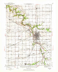
1925 Map of Streator
USGS Topo · Published 1964About this map
The Vermilion River carves a deep, winding path through the heart of the central Illinois prairie, anchoring an industrial and agricultural landscape centered on Streator. In the mid-1920s, this area was a hub of rail activity, where the Chicago Burlington and Quincy and the Atchison Topeka and Santa Fe cross paths, supporting the region's shipping and manufacturing. The map reveals a dense network of rural infrastructure, from the Coalville School to the German Methodist Church, reflecting the established ethnic and communal settlements of the era.
Find a feature on this map
99 named features on this map. Tap any name to fly to it.
Don’t see what you’re looking for? This feature index may not catch every label — zoom into the map to look around manually.
Map Details
Editions of this 1925 Streator Map
2 editions found
Other maps of this area

1892 · Marseilles
USGS Topo · 1:62,500

1892 · Ottawa
USGS Topo · 1:62,500

1893 · Lasalle
USGS Topo · 1:62,500

1911 · La Salle
USGS Topo · 1:62,500

1913 · La Salle
USGS Topo · 1:62,500

1915 · Ottawa
USGS Topo · 1:62,500

1916 · Marseilles
USGS Topo · 1:62,500

1927 · Streator
USGS Topo · 1:62,500

1934 · Wenona
USGS Topo · 1:48,000

1935 · Pontiac
USGS Topo · 1:62,500