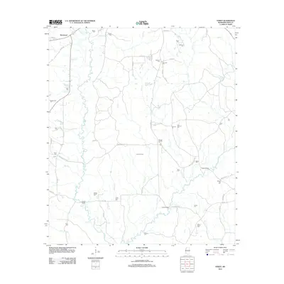
2012 Map of Street
USGS Topo · Published 2012About this map
The W Fork Amite River and E Fork Amite River define the hydraulic character of this corner of Amite County, where the settlement at Beechwood sits near the northern boundary. The landscape is a network of rural roads such as S Greensburg Rd and Mary Wall Bridge Rd, connecting small family farms and timber tracts. This map is exceptionally dense with small family burial grounds, providing a significant resource for genealogical research. Named cemeteries such as Agrippa Gayden Cem, Maxwell Hamilton Cem, and the Amite River Cem are scattered throughout the quadrangle, often tucked away from the main thoroughfares. Industrial activity is represented by the Liberty Oil Field in the central portion of the sheet, while historic crossings like Latimer Ford and Waller Bridge indicate long-established transit patterns across the river forks.
Find a feature on this map
68 named features on this map. Tap any name to fly to it.
Don’t see what you’re looking for? This feature index may not catch every label — zoom into the map to look around manually.
Map Details
Editions of this 2012 Street Map
This is the sole edition of this map. No revisions or reprints were ever made.
Other maps of this area

1941 · Woodland
USGS Topo · 1:31,680

1941 · Chipola
USGS Topo · 1:31,680

1942 · Liverpool
USGS Topo · 1:31,680

1945 · Chipola
USGS Topo · 1:31,680

1953 · Natchez
USGS Topo · 1:250,000

1954 · Baton Rouge
USGS Topo · 1:250,000

1956 · Natchez
USGS Topo · 1:250,000

1956 · Baton Rouge
USGS Topo · 1:250,000
1958 · Felixville
USGS Topo · 1:62,500
1958 · Kentwood
USGS Topo · 1:62,500