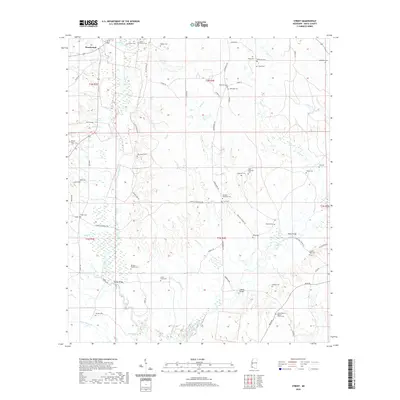
2020 Map of Street
USGS Topo · Published 2020About this map
The West Fork Amite River and East Fork Amite River carve through this section of Amite County, defining a landscape marked by numerous family burial grounds and small rural congregations. The settlement of Street serves as a local waypoint near the Street Cem, while Beechwood sits in the northwest. Genealogy is a primary focus of this record, which meticulously plots names like the Agrippa Gayden Cem, Stewart Wall Cem, and Davis - Tucker Cem. Civil infrastructure is represented by spans such as Harold Bridge and Waller Bridge, which facilitate travel across the river forks and their tributaries like Waggoner Cr and Powell Cr. Further south, the Mount Pilgrim Baptist Church and its associated cemetery stand as central community landmarks near the confluence of local routes like Bean Rd and Loop Rd.
Find a feature on this map
74 named features on this map. Tap any name to fly to it.
Don’t see what you’re looking for? This feature index may not catch every label — zoom into the map to look around manually.
Map Details
Editions of this 2020 Street Map
This is the sole edition of this map. No revisions or reprints were ever made.
Other maps of this area

1941 · Woodland
USGS Topo · 1:31,680

1941 · Chipola
USGS Topo · 1:31,680

1942 · Liverpool
USGS Topo · 1:31,680

1945 · Chipola
USGS Topo · 1:31,680

1953 · Natchez
USGS Topo · 1:250,000

1954 · Baton Rouge
USGS Topo · 1:250,000

1956 · Natchez
USGS Topo · 1:250,000

1956 · Baton Rouge
USGS Topo · 1:250,000
1958 · Felixville
USGS Topo · 1:62,500
1958 · Kentwood
USGS Topo · 1:62,500