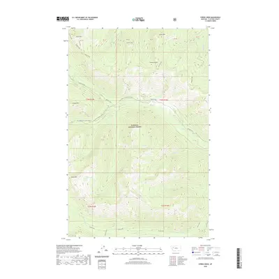
2020 Map of String Creek
USGS Topo · Published 2020About this map
Flathead National Forest encompasses this high-elevation landscape in northwestern Montana, defined by a series of prominent peaks and high alpine basins. The topography is anchored by Chipmunk Peak, Cinabar Mountain, and Tranquil Mountain, with drainage patterns moving through deep valleys carved by Bunker Creek and Gorge Creek. This 2020 survey illustrates a wilderness character where access is limited to established forest corridors like Natl Forest Develop Road 549 RD and the route along Middle Fork Bunker Creek. Several remote water bodies, including Late Lake, Alcove Lake, and Sunburst Lake, are tucked into the steep slopes, marking the headwaters of numerous small tributaries such as Feather Creek and Razzle Creek. The map provides a contemporary view of these protected public lands, detailing the specific drainages and summits that shape this part of the northern Rockies.
Find a feature on this map
34 named features on this map. Tap any name to fly to it.
Don’t see what you’re looking for? This feature index may not catch every label — zoom into the map to look around manually.
Map Details
Editions of this 2020 String Creek Map
This is the sole edition of this map. No revisions or reprints were ever made.
Other maps of this area

1936 · Silvertip
USGS Topo · 1:96,000

1942 · Silvertip
USGS Topo · 1:125,000

1955 · Choteau
USGS Topo · 1:250,000

1957 · Choteau
USGS Topo · 1:250,000

1958 · Choteau
USGS Topo · 1:250,000

1962 · Choteau
USGS Topo · 1:250,000
1965 · Connor Creek
USGS Topo · 1:24,000

1965 · Sunburst Lake
USGS Topo · 1:24,000
1965 · Tin Creek
USGS Topo · 1:24,000
1965 · Thunderbolt Mountain
USGS Topo · 1:24,000