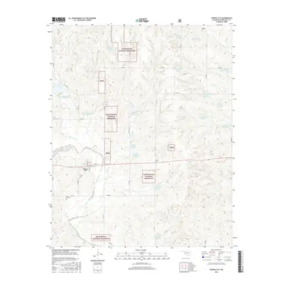
2016 Map of Strong City
USGS Topo · Published 2016About this map
Strong City serves as the primary hub in this western Oklahoma landscape, situated just north of the meandering Washita River. The surrounding area is characterized by the fragmented parcels of the Black Kettle National Grassland, which are interspersed with private holdings and an extensive network of reservoirs. These water management features, such as the Dead Indian-Wildhorse Site 2 Reservoir and Quartermaster Site 7 Reservoir, indicate the importance of soil conservation and water storage in this prairie environment. For those researching local history, the map provides precise locations for family-named sites like Sankey Cem and Wagoner Cem, alongside landmarks like Snake Bend Cem. The terrain is deeply etched by a drainage network including Wild Horse Cr, Coffey Cr, and Ninemile Cr, illustrating the rugged erosional patterns typical of the region's red beds.
Find a feature on this map
49 named features on this map. Tap any name to fly to it.
Don’t see what you’re looking for? This feature index may not catch every label — zoom into the map to look around manually.
Map Details
Editions of this 2016 Strong City Map
This is the sole edition of this map. No revisions or reprints were ever made.
Other maps of this area

1955 · Clinton
USGS Topo · 1:250,000

1957 · Clinton
USGS Topo · 1:250,000

1960 · Cheyenne
USGS Topo · 1:62,500

1960 · Hammon
USGS Topo · 1:62,500

1961 · Leedey
USGS Topo · 1:62,500

1966 · Roll
USGS Topo · 1:24,000

1966 · Roll SE
USGS Topo · 1:24,000

1984 · Foss Reservoir
USGS Topo · 1:100,000
1987 · Leedey SW
USGS Topo · 1:24,000

1987 · Big Kiowa Creek
USGS Topo · 1:24,000