
1969 Map of Strongs Knob
USGS Topo · Published 1985About this map
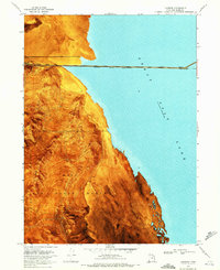
The industrial and military landscape of the Great Salt Lake desert is starkly revealed in this 1969 orthophotomosaic. The Southern Pacific (Lucin Cutoff) railroad dominates the northern expanse, traversing the vast Mud Flat to reach the prominent landmark of Strongs Knob. To the south, large-scale industrial activity is evident at the Evaporator Pond, supported by a Pumping Station and an Aqueduct near Lakeside Butte.
Find a feature on this map
19 named features on this map. Tap any name to fly to it.
Don’t see what you’re looking for? This feature index may not catch every label — zoom into the map to look around manually.
Map Details
Editions of this 1969 Strongs Knob Map
2 editions found
Other maps of this area

1954 · Brigham City
USGS Topo · 1:250,000

1958 · Brigham City
USGS Topo · 1:250,000

1962 · Brigham City
USGS Topo · 1:250,000

1968 · Deardens Knoll
USGS Topo · 1:24,000

1969 · Gunnison Island SW
USGS Topo · 1:24,000

1969 · Hogup Ridge South
USGS Topo · 1:24,000

1969 · Strongs Knob
USGS Topo · 1:24,000

1969 · Gunnison Island
USGS Topo · 1:24,000
1969 · Lakeside
USGS Topo · 1:24,000

1969 · Hogup Ridge North
USGS Topo · 1:24,000