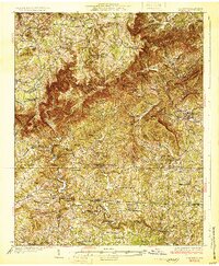
1931 Map of Stuart
USGS Topo · Published 1931About this map
Stuart serves as the focal point for this 1931 survey of the Blue Ridge escarpment, where the land drops sharply from the plateau into the Piedmont. The topographic detail highlights the dramatic Pinnacles of Dan, a series of sharp ridges where the Dan River carves through the mountains. Rural life in the early twentieth century is evidenced by a dense network of country schools and family mills, including Stonewall Jackson Sch, Milla Sch, and Union Mill. The map also captures the path of early motor routes such as State Highway No 8 and State Highway No 23, which connected mountain communities like Meadows of Dan and Vesta to the lowlands. This survey provides a precise look at the landscape before modern development, recording the specific locations of landmarks like Lovers Leap and numerous local churches including Bell Spur Ch and State Line Ch.
Find a feature on this map
89 named features on this map. Tap any name to fly to it.
Don’t see what you’re looking for? This feature index may not catch every label — zoom into the map to look around manually.
Map Details
Editions of this 1931 Stuart Map
3 editions found
Other maps of this area

1889 · Hillsville
USGS Topo · 1:125,000

1891 · Yadkinville
USGS Topo · 1:125,000

1892 · Hillsville
USGS Topo · 1:125,000

1893 · Yadkinville
USGS Topo · 1:125,000

1896 · Hillsville
USGS Topo · 1:125,000

1926 · Critz
USGS Topo · 1:48,000

1928 · Stuart
USGS Topo · 1:48,000

1928 · Critz
USGS Topo · 1:62,500

1931 · Stuart
USGS Topo · 1:62,500

1953 · Winston-Salem
USGS Topo · 1:250,000