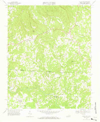
1968 Map of Stuart SE
USGS Topo · Published 1970About this map
The Dan River flows across the southern reaches of this landscape, anchoring a rural borderland where Patrick County, Virginia, and Stokes County, North Carolina, meet. This late-1960s survey captures a network of small agricultural settlements and mountain hollows connected by winding paths like State Line Road and Circle Road. The topography is defined by significant rises such as Gaines Mtn and Beans Knob, while the lowlands are carved by a dense web of waterways including Peters Creek, Elk Creek, and Russell Creek.
Find a feature on this map
47 named features on this map. Tap any name to fly to it.
Don’t see what you’re looking for? This feature index may not catch every label — zoom into the map to look around manually.
Map Details
Editions of this 1968 Stuart SE Map
3 editions found
Other maps of this area

1926 · Critz
USGS Topo · 1:48,000

1928 · Stuart
USGS Topo · 1:48,000

1928 · Critz
USGS Topo · 1:62,500

1931 · Stuart
USGS Topo · 1:62,500

1953 · Winston-Salem
USGS Topo · 1:250,000

1955 · Winston-Salem
USGS Topo · 1:250,000

1962 · Winston-Salem
USGS Topo · 1:250,000

1964 · Hanging Rock
USGS Topo · 1:24,000

1964 · Pilot Mountain
USGS Topo · 1:24,000

1967 · Patrick Springs
USGS Topo · 1:24,000