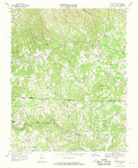
1968 Map of Stuart SE
USGS Topo · Published 1971About this map
The Dan River snakes through the southern half of this 1968 survey, defining a landscape of narrow bottomlands and prominent peaks along the Virginia and North Carolina border. The terrain is marked by significant elevations such as Pikes Mountain, Gaines Mtn, and Beans Knob, which separate the various tributaries feeding into the larger river system. Small communities and rural junctions like Francisco, Aarons Corner, and Five Forks are connected by a network of winding roads, including State Line Church RD and Tom Mix Road, reflecting the scattered settlement patterns of the Blue Ridge foothills during the late 1960s.
Find a feature on this map
50 named features on this map. Tap any name to fly to it.
Don’t see what you’re looking for? This feature index may not catch every label — zoom into the map to look around manually.
Map Details
Editions of this 1968 Stuart SE Map
3 editions found
Other maps of this area

1926 · Critz
USGS Topo · 1:48,000

1928 · Stuart
USGS Topo · 1:48,000

1928 · Critz
USGS Topo · 1:62,500

1931 · Stuart
USGS Topo · 1:62,500

1953 · Winston-Salem
USGS Topo · 1:250,000

1955 · Winston-Salem
USGS Topo · 1:250,000

1962 · Winston-Salem
USGS Topo · 1:250,000

1964 · Hanging Rock
USGS Topo · 1:24,000

1964 · Pilot Mountain
USGS Topo · 1:24,000

1967 · Patrick Springs
USGS Topo · 1:24,000