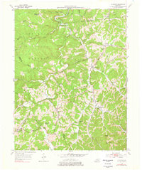
1953 Map of Sturgeon
USGS Topo · Published 1978About this map
Sturgeon Creek winds through this 1950s landscape of the Cumberland Plateau, defining a network of steep hollows and narrow ridges in Owsley and Jackson counties. The settlement pattern is strikingly decentralized, with community life anchored by numerous rural schools and churches such as Bethlehem Sch, Travis Sch, and the Warren Chapel overlooking Sturgeon Creek. Small hamlets like Travellers Rest, Earnestville, and Green Hall serve as local hubs for the surrounding farmsteads.
Find a feature on this map
83 named features on this map. Tap any name to fly to it.
Don’t see what you’re looking for? This feature index may not catch every label — zoom into the map to look around manually.
Map Details
Editions of this 1953 Sturgeon Map
4 editions found
Other maps of this area

1891 · Manchester
USGS Topo · 1:125,000

1892 · Beattyville
USGS Topo · 1:125,000

1952 · Leighton
USGS Topo · 1:24,000

1952 · Beattyville
USGS Topo · 1:24,000

1952 · Heidelberg
USGS Topo · 1:24,000

1953 · Mc Kee
USGS Topo · 1:24,000

1953 · Oneida
USGS Topo · 1:24,000

1953 · Tyner
USGS Topo · 1:24,000

1953 · Booneville
USGS Topo · 1:24,000

1953 · Sturgeon
USGS Topo · 1:24,000