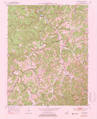
1953 Map of Sturgeon
USGS Topo · Published 1983About this map
Cumberland National Forest dominates the terrain of this Owsley County landscape, where the winding path of Sturgeon Creek and its many tributaries dictate the pattern of settlement. Remote rural life in the early 1950s is evidenced by the high density of small country schools and churches that served these hollows, including Bethlehem Sch, Royal Oak Sch, and Calvary Ch. The map captures several small communities such as Earnestville, Green Hall, and Vincent, many of which developed around the junction of creek forks like Spruce Fork and Little Sturgeon Creek. Scattered oil wells near Standing Rock indicate the localized extraction efforts that once operated alongside traditional agriculture. This survey provides a meticulous record of the road networks and family-named landmarks like Hunters Knob before modern infrastructure altered the more isolated character of the Kentucky river hills.
Find a feature on this map
50 named features on this map. Tap any name to fly to it.
Don’t see what you’re looking for? This feature index may not catch every label — zoom into the map to look around manually.
Map Details
Editions of this 1953 Sturgeon Map
4 editions found
Other maps of this area

1891 · Manchester
USGS Topo · 1:125,000

1892 · Beattyville
USGS Topo · 1:125,000

1952 · Leighton
USGS Topo · 1:24,000

1952 · Beattyville
USGS Topo · 1:24,000

1952 · Heidelberg
USGS Topo · 1:24,000

1953 · Mc Kee
USGS Topo · 1:24,000

1953 · Oneida
USGS Topo · 1:24,000

1953 · Tyner
USGS Topo · 1:24,000

1953 · Booneville
USGS Topo · 1:24,000

1953 · Sturgeon
USGS Topo · 1:24,000