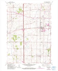
1959 Map of Sturtevant
USGS Topo · Published 1994About this map
Sturtevant and the industrial activity at Waxdale anchor this detailed look at eastern Wisconsin's landscape as it transitioned into the late 20th century. The intersection of rural history and emerging infrastructure is clear, with the Root River Canal and East Branch Root River Canal draining the surrounding townships of Yorkville, Mount Pleasant, and Paris. A dense network of one-room schoolhouses, such as Tucker Sch and Herzog Sch, alongside older community centers like Ives Grove, shows a pattern of settlement being reshaped by modern corridors. Small aviation history is represented by Sylvania Airport near the cross-roads of Sylvania, while recreational and spiritual sites like Petrifying Springs Park and St Bonaventure Sch indicate a maturing community. The map provides a precise record of the Racine and Kenosha county line, marking the boundaries between these farming and manufacturing hubs.
Find a feature on this map
45 named features on this map. Tap any name to fly to it.
Don’t see what you’re looking for? This feature index may not catch every label — zoom into the map to look around manually.
Map Details
Editions of this 1959 Sturtevant Map
4 editions found
Other maps of this area

1891 · Bayview
USGS Topo · 1:62,500

1891 · Muskego
USGS Topo · 1:62,500

1892 · Racine
USGS Topo · 1:62,500

1893 · Silver Lake
USGS Topo · 1:62,500

1901 · Bayview
USGS Topo · 1:62,500

1901 · Muskego
USGS Topo · 1:62,500

1905 · Racine
USGS Topo · 1:62,500

1906 · Silver Lake
USGS Topo · 1:62,500

1954 · Rockford
USGS Topo · 1:250,000

1955 · Rockford
USGS Topo · 1:250,000