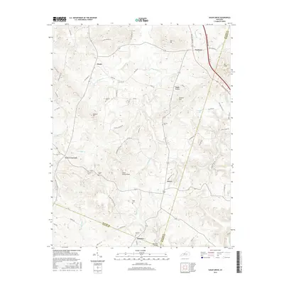
2016 Map of Sugar Grove
USGS Topo · Published 2016About this map
Richelieu sits at the southern edge of this territory where the Barren River meets the border of Butler, Logan, and Warren counties. The landscape is defined by its rural density, featuring a high concentration of family cemeteries such as Lee Cem, McKinney Cem, and Ragland Cemetery. These sites are scattered among the hills and hollows that rise toward Ragland Hill and Peach Orchard Knob. Small settlements like Dimple, Sharer, and Needmore are connected by a network of local roads that follow the drainage of Little Muddy Cr and Richland Cr.
Find a feature on this map
71 named features on this map. Tap any name to fly to it.
Don’t see what you’re looking for? This feature index may not catch every label — zoom into the map to look around manually.
Map Details
Editions of this 2016 Sugar Grove Map
This is the sole edition of this map. No revisions or reprints were ever made.
Other maps of this area

1911 · Dunmor
USGS Topo · 1:48,000

1914 · Little Muddy
USGS Topo · 1:62,500

1914 · Dunmor
USGS Topo · 1:62,500

1951 · South Union
USGS Topo · 1:24,000

1951 · Homer
USGS Topo · 1:24,000

1952 · Rockfield
USGS Topo · 1:24,000

1953 · South Hill
USGS Topo · 1:24,000

1953 · Quality
USGS Topo · 1:24,000

1954 · Evansville
USGS Topo · 1:250,000
1954 · Hadley
USGS Topo · 1:24,000