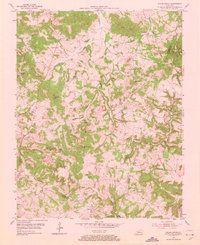
1954 Map of Sugar Grove
USGS Topo · Published 1973About this map
Little Muddy Creek and its many tributaries, including Richland Creek and Cane Ridge Creek, define the rolling landscape of this Kentucky region during the mid-1950s. The area is dotted with small rural communities and crossroad settlements such as Richland, Dimple, and Sugar Grove. This map reveals a high density of country churches and small family burial grounds, providing a detailed view of the local social and genealogical fabric. Notable landmarks like Durham Chapel and Stephens Chapel serve as anchor points for these communities. Along the southern edge, the Gasper River winds through the terrain near Richelieu, while the western hills are marked by prominent features like Peach Orchard Knob and Ragland Hill. The presence of Prospect Sch and numerous cemeteries like Shiloh Cem and Stewart Cem offers significant insight into the historical settlement patterns before later modernization.
Find a feature on this map
49 named features on this map. Tap any name to fly to it.
Don’t see what you’re looking for? This feature index may not catch every label — zoom into the map to look around manually.
Map Details
Editions of this 1954 Sugar Grove Map
2 editions found
Other maps of this area

1911 · Dunmor
USGS Topo · 1:48,000

1914 · Little Muddy
USGS Topo · 1:62,500

1914 · Dunmor
USGS Topo · 1:62,500

1951 · South Union
USGS Topo · 1:24,000

1951 · Homer
USGS Topo · 1:24,000

1952 · Rockfield
USGS Topo · 1:24,000

1953 · South Hill
USGS Topo · 1:24,000

1953 · Quality
USGS Topo · 1:24,000

1954 · Evansville
USGS Topo · 1:250,000
1954 · Hadley
USGS Topo · 1:24,000