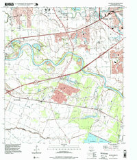
1995 Map of Sugar Land
USGS Topo · Published 1999About this map
The Brazos River snakes through the heart of this Fort Bend County landscape, creating a complex network of oxbows and sloughs like Old River Lake and Gapps Slough. Significant portions of the terrain are dedicated to institutional use, notably the Jester State Prison Farm and Central State Prison Farm, which dominate the central and northern sections. The map captures the suburban expansion of Sugar Land and Rosenberg alongside older, smaller settlements such as Crabb and Booth. Local history is preserved through numerous rural landmarks, including Thompson Chapel, Zion Hill Ch, and the Sandberry Cem. Industrial and recreational features like the Sugar Land Municipal Airport and Pecan Grove Country Club highlight the mid-1990s transition from agricultural and institutional land towards residential and commercial development.
Find a feature on this map
51 named features on this map. Tap any name to fly to it.
Don’t see what you’re looking for? This feature index may not catch every label — zoom into the map to look around manually.
Map Details
Editions of this 1995 Sugar Land Map
This is the sole edition of this map. No revisions or reprints were ever made.
Other maps of this area

1915 · Alief
USGS Topo · 1:24,000

1915 · Clodine
USGS Topo · 1:24,000

1919 · Clodine
USGS Topo · 1:31,680

1950 · Houston
USGS Topo · 1:250,000

1953 · Needville
USGS Topo · 1:24,000

1953 · Lake George
USGS Topo · 1:24,000

1953 · Thompsons
USGS Topo · 1:24,000

1955 · Sugar Land
USGS Topo · 1:62,500

1955 · Richmond
USGS Topo · 1:62,500

1956 · Houston
USGS Topo · 1:250,000