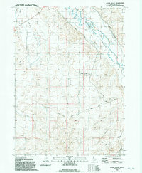
1992 Map of Sugar Valley
USGS Topo · Published 1992About this map
The Bruneau River corridor defines this portion of Owyhee County, where late 20th-century irrigation infrastructure meets the high desert landscape. The map details a complex water management system including the South Side Canal, Hot Springs Ditch, and Bieroth Canal, which supported the agricultural operations in the valley. A unique geographical transition is evident where the river flows through the Snake River Birds of Prey Area in the north, while the southern terrain rises toward Horse Hill and the distinctive formations of the City of Rocks.
Find a feature on this map
24 named features on this map. Tap any name to fly to it.
Don’t see what you’re looking for? This feature index may not catch every label — zoom into the map to look around manually.
Map Details
Editions of this 1992 Sugar Valley Map
This is the sole edition of this map. No revisions or reprints were ever made.
Other maps of this area

1946 · Mouth of Bruneau
USGS Topo · 1:24,000

1947 · Little Valley
USGS Topo · 1:24,000

1947 · Bruneau
USGS Topo · 1:62,500

1947 · Sand Dunes
USGS Topo · 1:24,000

1947 · Bruneau
USGS Topo · 1:24,000

1947 · Sugar Valley
USGS Topo · 1:24,000

1947 · Hot Spring
USGS Topo · 1:24,000

1948 · Sand Dunes
USGS Topo · 1:24,000
1948 · Little Valley
USGS Topo · 1:24,000

1948 · Sugar Valley
USGS Topo · 1:24,000