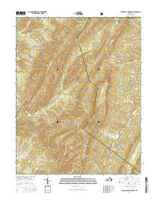
2016 Map of Sugarloaf Mountain
USGS Topo · Published 2016About this map
George Washington National Forest and Jefferson National Forest meet in this 2016 survey, defining a landscape of prominent ridges and deep hollows. The terrain is anchored by peaks like Sugarloaf Mtn and Mt Pisgah, with the southern extent of the Lexington Reservoir visible in the northeast corner. Cultural features are concentrated along the lower elevations, particularly near Rapps Mill and the small settlement of Reidland. The map reveals the intricate network of drainage systems feeding the James River watershed, including S Buffalo Cr and Purgatory Cr. For local historians and genealogists, the inclusion of Rapps Cem, Pullen Cem, and Deacons Cem provides vital markers of family heritage within the Rockbridge and Botetourt county borderlands. The road system, including the Bluegrass Trl, follows the natural contours of the mountain gaps, illustrating the enduring influence of topography on regional travel.
Find a feature on this map
72 named features on this map. Tap any name to fly to it.
Don’t see what you’re looking for? This feature index may not catch every label — zoom into the map to look around manually.
Map Details
Editions of this 2016 Sugarloaf Mountain Map
This is the sole edition of this map. No revisions or reprints were ever made.
Other maps of this area

1894 · Natural Bridge
USGS Topo · 1:125,000

1894 · Natural Bridge
USGS Topo · 1:62,500

1907 · Natural Bridge Special
USGS Topo · 1:62,500

1913 · Eagle Rock
USGS Topo · 1:48,000

1915 · Eagle Rock
USGS Topo · 1:62,500

1945 · Clifton Forge
USGS Topo · 1:62,500

1946 · Millboro
USGS Topo · 1:62,500

1947 · Roanoke
USGS Topo · 1:250,000
1949 · Clifton Forge
USGS Topo · 1:62,500
1949 · Millboro
USGS Topo · 1:62,500