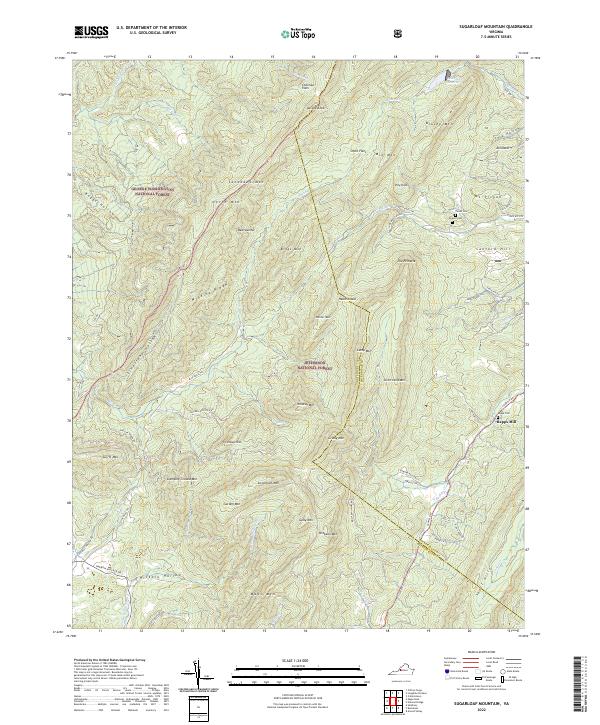
2022 Map of Sugarloaf Mountain
USGS Topo · Published 2022About this map
George Washington National Forest and Jefferson National Forest dominate this landscape along the Botetourt and Rockbridge County line. The terrain is defined by a series of parallel ridges and high peaks, including North Mtn, Painter Mtn, and the distinctive Sugarloaf Mtn. The small settlement of Rapps Mill sits along the banks of S Buffalo Cr, representing the modest agricultural and milling operations that once utilized these mountain waters. Nearby, local history is preserved at Rapps Cem, while further north near Reidland, the Pullen Cem and Deacon Cem offer sites for genealogical research. The northern edge is marked by the Lexington Reservoir, illustrating the area's role in regional water management. Numerous gaps and hollows, such as Boggs Hollow and Tory Hollow, suggest historical transit routes through this complex topography.
Find a feature on this map
78 named features on this map. Tap any name to fly to it.
Don’t see what you’re looking for? This feature index may not catch every label — zoom into the map to look around manually.
Map Details
Editions of this 2022 Sugarloaf Mountain Map
This is the sole edition of this map. No revisions or reprints were ever made.
Other maps of this area

1894 · Natural Bridge
USGS Topo · 1:125,000

1894 · Natural Bridge
USGS Topo · 1:62,500

1907 · Natural Bridge Special
USGS Topo · 1:62,500

1913 · Eagle Rock
USGS Topo · 1:48,000

1915 · Eagle Rock
USGS Topo · 1:62,500

1945 · Clifton Forge
USGS Topo · 1:62,500

1946 · Millboro
USGS Topo · 1:62,500

1947 · Roanoke
USGS Topo · 1:250,000
1949 · Clifton Forge
USGS Topo · 1:62,500
1949 · Millboro
USGS Topo · 1:62,500