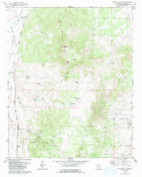
1979 Map of Sullivan Buttes
USGS Topo · Published 1985About this map
Sullivan Buttes dominate the center of this terrain, characterized by a series of peaks and volcanic landforms north of Prescott. The landscape is defined by the high point at Simmons Peak and the drainage patterns of Williamson Valley Wash and Mint Wash. Human activity in the late 1970s was primarily centered on ranching and the railroad corridor. The Atchison Topeka and Santa Fe railroad line runs along the western edge of the quadrangle, serving local transport needs at Tucker Siding. Numerous water management features, such as Miller Dam Tank, Maxwell Tank, and Scissor Tank, are scattered across the area to support livestock at operations like Matli Ranch. Local geography is further marked by prominent canyons including Dillon Canyon and the notable Inscription Canyon.
Find a feature on this map
22 named features on this map. Tap any name to fly to it.
Don’t see what you’re looking for? This feature index may not catch every label — zoom into the map to look around manually.
Map Details
Editions of this 1979 Sullivan Buttes Map
3 editions found
Other maps of this area

1887 · Prescott
USGS Topo · 1:250,000

1892 · Prescott
USGS Topo · 1:250,000

1905 · Jerome
USGS Topo · 1:125,000

1947 · Simmons
USGS Topo · 1:62,500

1947 · Iron Springs
USGS Topo · 1:62,500

1947 · Paulden
USGS Topo · 1:62,500

1947 · Prescott
USGS Topo · 1:62,500

1948 · Iron Springs
USGS Topo · 1:63,360

1948 · Prescott
USGS Topo · 1:62,500

1948 · Simmons
USGS Topo · 1:63,360