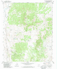
1979 Map of Sullivan Buttes
USGS Topo · Published 1985About this map
Sullivan Buttes and Simmons Peak dominate the high ground of this Arizona landscape, which in the late 1970s remained a working cattle and transit corridor. The Atchison Topeka and Santa Fe railroad tracks cut through the western valleys, serving local points like Tucker Siding near the confluence of Williamson Valley Wash and Mint Wash. The reliance on seasonal water in this arid terrain is evidenced by a dense network of catchment basins such as Pemberton Tank, Scissor Tank, and Miller Dam Tank. Small-scale ranching operations like Maiti Ranch are tucked into the drainages of Dillon Wash and Cooper Wash. Cultural history is marked by the winding path of Inscription Canyon in the southern portion of the map, while a Gaging Station monitors the intermittent flow of the valley's primary washes.
Find a feature on this map
25 named features on this map. Tap any name to fly to it.
Don’t see what you’re looking for? This feature index may not catch every label — zoom into the map to look around manually.
Map Details
Editions of this 1979 Sullivan Buttes Map
3 editions found
Other maps of this area

1887 · Prescott
USGS Topo · 1:250,000

1892 · Prescott
USGS Topo · 1:250,000

1905 · Jerome
USGS Topo · 1:125,000

1947 · Simmons
USGS Topo · 1:62,500

1947 · Iron Springs
USGS Topo · 1:62,500

1947 · Paulden
USGS Topo · 1:62,500

1947 · Prescott
USGS Topo · 1:62,500

1948 · Iron Springs
USGS Topo · 1:63,360

1948 · Prescott
USGS Topo · 1:62,500

1948 · Simmons
USGS Topo · 1:63,360