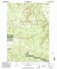
1995 Map of Sullivan Gulch
USGS Topo · Published 1998About this map
Starkey Experimental Forest and the surrounding wilderness of the Wallowa-Whitman and Umatilla National Forests dominate this interior Oregon landscape. This mid-1990s record captures the region's focus on forest management and ecology, centered on the Experimental Forest Headquarters and a network of named springs like Sardine Spring, Blarney Spring, and Doherty Spring. The topography is defined by the sharp descent of Sullivan Gulch and the winding course of Camas Creek, where numerous Gravel Pits are noted along the roads.
Find a feature on this map
35 named features on this map. Tap any name to fly to it.
Don’t see what you’re looking for? This feature index may not catch every label — zoom into the map to look around manually.
Map Details
Editions of this 1995 Sullivan Gulch Map
This is the sole edition of this map. No revisions or reprints were ever made.
Other maps of this area

1953 · Pendleton
USGS Topo · 1:250,000

1956 · Pendleton
USGS Topo · 1:250,000

1964 · Mc Intyre Creek
USGS Topo · 1:24,000

1965 · Marley Creek
USGS Topo · 1:24,000

1965 · Fly Valley
USGS Topo · 1:24,000

1967 · Tower Mtn
USGS Topo · 1:24,000

1967 · Sullivan Gulch
USGS Topo · 1:24,000

1967 · Lehman Springs
USGS Topo · 1:24,000

1967 · Bally Mountain
USGS Topo · 1:24,000

1967 · Pearson Ridge
USGS Topo · 1:24,000