
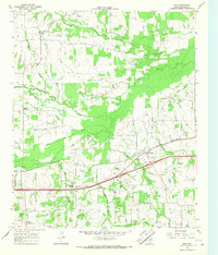
1962 Map of Sulphur Bluff
USGS Topo · Published 1964About this map
The South Sulphur River forms a winding natural boundary between Delta and Hopkins Counties at the northern edge of this Northeast Texas landscape. The village of Sulphur Bluff serves as the primary regional hub, surrounded by smaller community clusters such as Nelta and Flora. This 1960s-era topography illustrates a rural economy transitioning from traditional farming toward energy extraction, evidenced by scattered Oil Wells and a major utility pipeline cutting across the eastern fields.
Find a feature on this map
18 named features on this map. Tap any name to fly to it.
Don’t see what you’re looking for? This feature index may not catch every label — zoom into the map to look around manually.
Map Details
Editions of this 1962 Sulphur Bluff Map
This is the sole edition of this map. No revisions or reprints were ever made.
Other maps of this area

1953 · Texarkana
USGS Topo · 1:250,000

1956 · Texarkana
USGS Topo · 1:250,000

1963 · Mitchell Creek
USGS Topo · 1:24,000

1963 · Minter
USGS Topo · 1:24,000

1963 · Cunningham
USGS Topo · 1:24,000

1964 · Saltillo
USGS Topo · 1:24,000

1964 · Sulphur Springs
USGS Topo · 1:24,000

1964 · Charleston
USGS Topo · 1:24,000

1964 · Tira
USGS Topo · 1:24,000
1965 · Dike
USGS Topo · 1:24,000