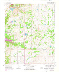
1963 Map of Sulphur South
USGS Topo · Published 1978About this map
Platt National Park anchors the northern boundary of this topographic record, showcasing the developed landscape around Sulphur during the early 1960s. The map highlights significant public works and institutional landmarks, including the State Veterans Hospital and Veterans Lake. To the south, the terrain transitions into the rural townships of Lowrance and Morgan, where the economy appears tied to the land through numerous features like the Fish Hatchery and several gravel pits. Small communities and family history sites are well-preserved here, specifically the settlement at Drake and the Central Church. Water is a defining element of the local geography, with Buckhorn Creek, Mill Creek, and Lowrance Springs carving through the countryside. Genealogists will find particular value in the clearly marked burial grounds, such as Buckhorn Cemetery and Fletcher Cemetery, which serve as quiet markers of the area's early residents.
Find a feature on this map
26 named features on this map. Tap any name to fly to it.
Don’t see what you’re looking for? This feature index may not catch every label — zoom into the map to look around manually.
Map Details
Editions of this 1963 Sulphur South Map
2 editions found
Other maps of this area

1898 · Pauls Valley
USGS Topo · 1:125,000

1901 · Stonewall
USGS Topo · 1:125,000

1901 · Tishomingo
USGS Topo · 1:125,000

1901 · Ardmore
USGS Topo · 1:125,000

1902 · Pauls Valley
USGS Topo · 1:125,000

1918 · Ardmore
USGS Topo · 1:125,000

1957 · Ardmore
USGS Topo · 1:250,000

1963 · Ardmore
USGS Topo · 1:250,000

1963 · Sulphur South
USGS Topo · 1:24,000

1963 · Mill Creek
USGS Topo · 1:24,000